


OUR BUSINESS
High Mountain Surveying was started in 2005 by Wade Wilde and Paul Ferry. Wade and Paul both worked for Wade’s father Kent for more than ten years at Wilde Land Surveying. While at Wilde Land Surveying, they were involved in numerous boundary surveys and subdivisions throughout Summit County.
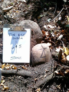
During that time, Kent was the contract county surveyor and performed the majority of the County Surveyor duties and was heavily involved with the monument preservation program in Summit County. This program gave each of them heavy exposure to the public land survey system in which many original section corner and quarter section corner stones were recovered, referenced and often replaced with aluminum pipe and caps.
In 2005, Kent decided to scale back his survey work load and increase his fishing hours. Thus, High Mountain Surveying began its first year of business. High Mountain Surveying also functions as the contract county surveyor for Summit County. Their many years of experience in Summit County have provided them with great insight and knowledge of the local area.
They are extremely proficient in GPS survey methods using both Leica and Topcon systems. GPS methods such and OPUS and the State VRS network have allowed them to work on a seamless blanket of control throughout the county. In addition to their survey skills of locating boundaries, they are experienced with the Summit County Planning Department and their development process in helping their clients achieve planning and development objectives.


WADE WILDE (OWNER)
I was born and raised in the Coalville area. I graduated from North Summit High School. I attended Weber State University and earned a dual BA Degree. I later attended Salt Lake Community College and earned an Associate Degree in Surveying. I became a Licensed Land Surveyor in 2000. My father is a Licensed Land Surveyor. I worked part time for him from 1985 until 1998, when I started working for him on a full-time basis. I worked for him in his business, Wilde Land Surveying, until 2005, when my partner, Paul Ferry, and I opened our own business, High Mountain Surveying. While attending college I also worked for two construction companies in the Salt Lake area. I really enjoy living and working in Summit County. I enjoy working in the surveying profession because of the time I am able to spend outdoors and the association I have with many different types of clients. I am married and currently raising a family in Hoytsville. In my spare time I enjoy raising cattle on the family farm, hunting and fishing, and spending time outdoors with my family.

PAUL FERRY
Paul Grew up in Henefer Utah were he acquired a large appetite for hunting and fishing. Upon graduation from High School, he attended Dixie College and graduated with an Associate of Arts Degree. He earned his Bachelor degree from Weber State University and later received his degree in Surveying from Salt Lake Community College. Paul has held a Professional License in the State of Utah since 2000. A member of the Utah Council of Land Surveyors, Paul has served as the past Vice President of the Golden Spike Chapter on three different occasions. Paul continues to live in Henefer where he and his wife are raising four girls. When not surveying, he stays busy as the local scoutmaster, taking his family camping and teaching his daughters to tie flies.
Copyright© 2011 High Mountain Surveying all rights reserved.
Design: CreativeWebDesign